Hirnant Forest Resource Plan
Overview
Natural Resources Wales is responsible for the sustainable management of the publicly owned woodlands and forests of Wales. They are managed for the benefit and well-being of the people who visit them and depend on them for their livelihood. This responsibility includes improving their biodiversity and long-term resilience to climate change so that future generations will also be able to enjoy the benefits they provide. Every ten years Natural Resources Wales reviews the long-term management plans for each forest area. These are compiled in a new Forest Resource Plan.
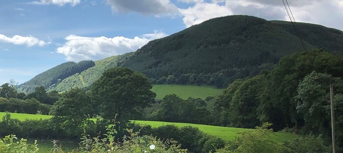
Hirnant Forest Resource Plan (FRP) includes the main forest blocks of Cwmwr and Cwm Gwnen which collectively have a total area of 257.21 ha (Cwmwr 128.88 ha and Cwm Gwnen 128.33 ha). These two forest blocks are referred to as ‘Hirnant’ so named after the small village of Hirnant or the Hirnant stream/valley which is located to the south of Cwmwr. The name Cwmwr or ‘footbridge’, has been taken from the surrounding farmsteads names which perhaps referred to a historic footbridge over the Hirnant stream.
The two Hirnant forest blocks are situated within the County Council boundary of Powys. Cwmwr is located on a steep hillside (Carnedd Das Eithin) and the Bwlch y Main ridge to the north of the B439, Abertridwr to Penybontfawr road. Cwm Gwnen is approached by a minor public road from the village of Penygarnedd B4391, north of Llanfyllin.
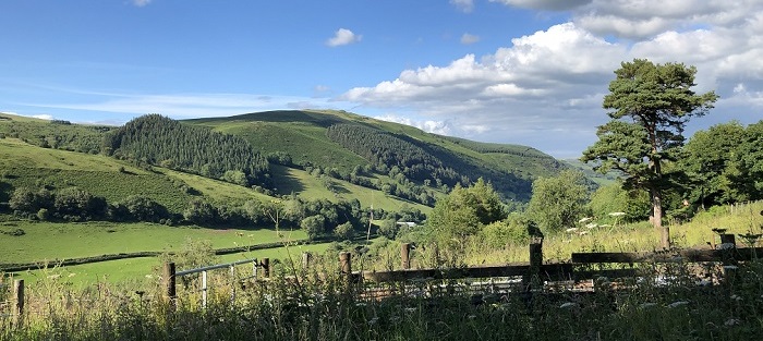
The surrounding habitat of the Hirnant FRP blocks consists of enclosed grazed farmland, commercial conifer forest blocks, which dominate the higher elevations and mixed broadleaved woodlands on the lower slopes and riversides. The Berwyn NNR, (SAC, SPA and SSSI) is situated 1.2km to the west and north of the Hirnant FRP, which consists of nearly 8000 hectares of open moorland within the Berwyn Mountain range.
Public access for the two woodlands is a mixture of open access on foot with a good network of public footpaths and bridleways linking the woodland blocks to the wider landscape.
Below is a link to the summary of objectives for the plan followed by the indicative maps for the forest resource plan:
Hirnant Forest Summary of Objectives
The following document helps to explain some of the categories shown on the maps below:
Summary of the main changes that will occur in the forest:
- The removal of all larch trees from the woodlands (20ha) due to the confirmation of Phytophthora ramorum
- Enhancement of higher conservation value areas by the management and expansion of the riparian zones and successional woodland.
- An increase of areas allocated to long term retention and natural reserves.
- The restoration of ancient woodland sites (6ha) by the removal of conifer and the creation of a native broadleaf habitat.
- Softening of conifer edges to lessen their visual impact on the landscape
- A decrease of Sitka spruce and an increase of other species of conifer and broadleaves in order to increase the woodlands resilience to pests and diseases
Why your views matter
We would like to know your opinion and views on the new plans for Hirnant forest so it can help us improve its long-term management.
Areas
- Aber Valley
- Aber-craf
- Aberaeron
- Aberaman North
- Aberaman South
- Aberavon
- Aberbargoed
- Abercarn
- Abercynon
- Aberdare East
- Aberdare West/Llwydcoed
- Aberdaron
- Aberdovey
- Aberdulais
- Abererch
- Abergele Pensarn
- Abergwili
- Aberkenfig
- Abermaw
- Aberporth
- Abersoch
- Abersychan
- Aberteifi/Cardigan-Mwldan
- Aberteifi/Cardigan-Rhyd-y-Fuwch
- Aberteifi/Cardigan-Teifi
- Abertillery
- Aberystwyth Bronglais
- Aberystwyth Canol/Central
- Aberystwyth Gogledd/North
- Aberystwyth Penparcau
- Aberystwyth Rheidol
- Acton
- Adamsdown
- Aethwy
- Allt-wen
- Allt-yr-yn
- Alway
- Ammanford
- Amroth
- Argoed
- Arllechwedd
- Aston
- Badminton
- Bagillt East
- Bagillt West
- Baglan
- Bala
- Banwy
- Bargoed
- Baruc
- Beaufort
- Beddau
- Bedlinog
- Bedwas, Trethomas and Machen
- Beechwood
- Beguildy
- Berriew
- Bethel
- Bettws
- Betws
- Betws yn Rhos
- Betws-y-Coed
- Beulah
- Bigyn
- Bishopston
- Blackmill
- Blackwood
- Blaen Hafren
- Blaenavon
- Blaengarw
- Blaengwrach
- Blaina
- Bodelwyddan
- Bontnewydd
- Bonymaen
- Borras Park
- Borth
- Botwnnog
- Bowydd and Rhiw
- Brackla
- Brithdir and Llanfachreth/Ganllwyd/Llanelltyd
- Briton Ferry East
- Briton Ferry West
- Bro Aberffraw
- Bro Rhosyr
- Bronington
- Bronllys
- Broughton North East
- Broughton South
- Brymbo
- Bryn
- Bryn and Cwmavon
- Bryn Cefn
- Bryn-coch North
- Bryn-coch South
- Bryn-crug/Llanfihangel
- Bryncethin
- Bryncoch
- Brynford
- Brynmawr
- Brynna
- Bryntirion, Laleston and Merthyr Mawr
- Brynwern
- Brynyffynnon
- Buckley Bistre East
- Buckley Bistre West
- Buckley Mountain
- Buckley Pentrobin
- Builth
- Burry Port
- Burton
- Butetown
- Buttrills
- Bwlch
- Bynea
- Cadnant
- Cadoc
- Cadoxton
- Caerau
- Caergwrle
- Caergybi
- Caerhun
- Caerleon
- Caersws
- Caerwent
- Caerwys
- Caldicot Castle
- Camrose
- Canolbarth Môn
- Canton
- Cantref
- Capel Dewi
- Capelulo
- Carew
- Carmarthen Town North
- Carmarthen Town South
- Carmarthen Town West
- Cartrefle
- Castle
- Castleland
- Cathays
- Cefn
- Cefn Cribwr
- Cefn Fforest
- Cefn Glas
- Cenarth
- Ceulanamaesmawr
- Chirk North
- Chirk South
- Church Village
- Churchstoke
- Cilcain
- Cilfynydd
- Cilgerran
- Ciliau Aeron
- Cilycwm
- Cimla
- Clydach
- Clydau
- Clynnog
- Cockett
- Coed Eva
- Coedffranc Central
- Coedffranc North
- Coedffranc West
- Coedpoeth
- Coity
- Colwyn
- Connah's Quay Central
- Connah's Quay Golftyn
- Connah's Quay South
- Connah's Quay Wepre
- Conwy
- Cornelly
- Cornerswell
- Corris/Mawddwy
- Corwen
- Court
- Cowbridge
- Coychurch Lower
- Craig-y-Don
- Creigiau/St. Fagans
- Criccieth
- Crickhowell
- Croesonen
- Croesyceiliog North
- Croesyceiliog South
- Crosskeys
- Crucorney
- Crumlin
- Crwst
- Crymych
- Crynant
- Cwm
- Cwm Clydach
- Cwm-twrch
- Cwm-y-Glo
- Cwmbach
- Cwmbwrla
- Cwmllynfell
- Cwmtillery
- Cwmyniscoy
- Cyfarthfa
- Cymmer
- Cyncoed
- Cynwyl Elfed
- Cynwyl Gaeo
- Dafen
- Darren Valley
- Deganwy
- Deiniol
- Deiniolen
- Denbigh Central
- Denbigh Lower
- Denbigh Upper/Henllan
- Devauden
- Dewi
- Dewstow
- Diffwys and Maenofferen
- Dinas Cross
- Dinas Powys
- Disserth and Trecoed
- Dixton with Osbaston
- Dolbenmaen
- Dolforwyn
- Dolgellau North
- Dolgellau South
- Dowlais
- Drybridge
- Dunvant
- Dyfan
- Dyffryn
- Dyffryn Ardudwy
- Dyffryn Ceiriog/Ceiriog Valley
- Dyserth
- East Williamston
- Ebbw Vale North
- Ebbw Vale South
- Efail-newydd/Buan
- Efenechtyd
- Eglwysbach
- Eirias
- Elli
- Ely
- Erddig
- Esclusham
- Ewloe
- Faenor
- Fairwater
- Fairwood
- Felin-fâch
- Felindre
- Felinfoel
- Ferndale
- Ffynnongroyw
- Fishguard North East
- Fishguard North West
- Flint Castle
- Flint Coleshill
- Flint Oakenholt
- Flint Trelawny
- Forden
- Gabalfa
- Gaer
- Garden Village
- Garnant
- Garth
- Gele
- Georgetown
- Gerlan
- Gibbonsdown
- Gilfach
- Gilfach Goch
- Glanamman
- Glantwymyn
- Glanymor
- Glasbury
- Glyder
- Glyn
- Glyncoch
- Glyncorrwg
- Glynneath
- Godre'r graig
- Goetre Fawr
- Gogarth
- Goodwick
- Gorseinon
- Gorslas
- Gower
- Gowerton
- Graig
- Grangetown
- Green Lane
- Greenfield
- Greenmeadow
- Gresford East and West
- Groeslon
- Grofield
- Gronant
- Grosvenor
- Guilsfield
- Gurnos
- Gwaun-Cae-Gurwen
- Gwenfro
- Gwernaffield
- Gwernyfed
- Gwernymynydd
- Gwersyllt East and South
- Gwersyllt North
- Gwersyllt West
- Gwynfi
- Halkyn
- Harlech
- Haverfordwest: Castle
- Haverfordwest: Garth
- Haverfordwest: Portfield
- Haverfordwest: Prendergast
- Haverfordwest: Priory
- Hawarden
- Hawthorn
- Hay
- Heath
- Hendre
- Hendy
- Hengoed
- Hermitage
- Higher Kinnerton
- Hirael
- Hirwaun
- Holt
- Holywell Central
- Holywell East
- Holywell West
- Hope
- Hundleton
- Illtyd
- Johnston
- Johnstown
- Kerry
- Kidwelly
- Kilgetty/Begelly
- Killay North
- Killay South
- Kingsbridge
- Kinmel Bay
- Knighton
- Lampeter
- Lampeter Velfrey
- Lamphey
- Landore
- Langstone
- Lansdown
- Larkfield
- Laugharne Township
- Leeswood
- Letterston
- Lisvane
- Liswerry
- Litchard
- Little Acton
- Llanaelhaearn
- Llanafanfawr
- Llanarmon-yn-Ial/Llandegla
- Llanarth
- Llanbadarn Fawr
- Llanbadarn Fawr-Padarn
- Llanbadarn Fawr-Sulien
- Llanbadoc
- Llanbedr
- Llanbedr Dyffryn Clwyd/Llangynhafal
- Llanbedrog
- Llanberis
- Llanboidy
- Llanbradach
- Llanbrynmair
- Llandaff
- Llandaff North
- Llanddarog
- Llandderfel
- Llanddulas
- Llandeilo
- Llandinam
- Llandough
- Llandovery
- Llandow/Ewenny
- Llandrillo
- Llandrillo yn Rhos
- Llandrindod East/Llandrindod West
- Llandrindod North
- Llandrindod South
- Llandrinio
- Llandybie
- Llandyfriog
- Llandyrnog
- Llandysilio
- Llandysilio-gogo
- Llandysul Town
- Llanegwad
- Llanelly Hill
- Llanelwedd
- Llanengan
- Llanfair Caereinion
- Llanfair Dyffryn Clwyd/Gwyddelwern
- Llanfarian
- Llanfihangel
- Llanfihangel Aberbythych
- Llanfihangel Ystrad
- Llanfihangel-ar-Arth
- Llanfoist Fawr
- Llanfyllin
- Llanfynydd
- Llangadog
- Llangattock
- Llangeinor
- Llangeitho
- Llangeler
- Llangelynin
- Llangennech
- Llangernyw
- Llangewydd and Brynhyfryd
- Llangollen
- Llangollen Rural
- Llangors
- Llangunllo
- Llangunnor
- Llangwm
- Llangybi
- Llangybi Fawr
- Llangyfelach
- Llangyndeyrn
- Llangynidr
- Llangynwyd
- Llanharan
- Llanharry
- Llanhilleth
- Llanidloes
- Llanishen
- Llanllyfni
- Llannon
- Llanover
- Llanrhaeadr-ym-Mochnant/Llansilin
- Llanrhaeadr-yng-Nghinmeirch
- Llanrhian
- Llanrhystyd
- Llanrug
- Llanrumney
- Llansamlet
- Llansanffraid
- Llansannan
- Llansantffraed
- Llansantffraid
- Llansteffan
- Llantarnam
- Llantilio Crossenny
- Llantrisant Town
- Llantwit Fardre
- Llantwit Major
- Llanuwchllyn
- Llanwddyn
- Llanwenarth Ultra
- Llanwenog
- Llanwern
- Llanwnda
- Llanwrtyd Wells
- Llanybydder
- Llanyrafon East and Ponthir
- Llanyrafon West
- Llanyre
- Llanystumdwy
- Llay
- Lledrod
- Lliedi
- Llifôn
- Lligwy
- Llwyn-y-pia
- Llwynhendy
- Llysfaen
- Lower Brynamman
- Lower Loughor
- Machynlleth
- Maenclochog
- Maerdy
- Maescar/Llywel
- Maesteg East
- Maesteg West
- Maesycwmmer
- Maesydre
- Malpas
- Mancot
- Manorbier
- Manordeilo and Salem
- Marchog
- Marchwiel
- Mardy
- Marford and Hoseley
- Margam
- Marl
- Marshfield
- Martletwy
- Mawr
- Mayals
- Meifod
- Melindwr
- Menai (Bangor)
- Menai (Caernarfon)
- Merlin's Bridge
- Merthyr Vale
- Milford: Central
- Milford: East
- Milford: Hakin
- Milford: Hubberston
- Milford: North
- Milford: West
- Mill
- Minera
- Mitchel Troy
- Mochdre
- Mold Broncoed
- Mold East
- Mold South
- Mold West
- Montgomery
- Morfa
- Morfa Nefyn
- Morgan Jones
- Moriah
- Morriston
- Mostyn
- Mountain Ash East
- Mountain Ash West
- Mynyddbach
- Nant-y-moel
- Nantmel
- Nantyglo
- Narberth
- Narberth Rural
- Neath East
- Neath North
- Neath South
- Nefyn
- Nelson
- New Brighton
- New Broughton
- New Inn
- New Quay
- New Tredegar
- Newbridge
- Newcastle
- Newport
- Newton
- Newtown Central
- Newtown East
- Newtown Llanllwchaiarn North
- Newtown Llanllwchaiarn West
- Newtown South
- Neyland: East
- Neyland: West
- Northop
- Northop Hall
- Nottage
- Offa
- Ogmore Vale
- Ogwen
- Old Radnor
- Oldcastle
- Onllwyn
- Overmonnow
- Overton
- Oystermouth
- Pandy
- Pant
- Pant-yr-afon/Penmaenan
- Panteg
- Park
- Peblig (Caernarfon)
- Pelenna
- Pembrey
- Pembroke Dock: Central
- Pembroke Dock: Llanion
- Pembroke Dock: Market
- Pembroke Dock: Pennar
- Pembroke: Monkton
- Pembroke: St. Mary North
- Pembroke: St. Mary South
- Pembroke: St. Michael
- Pen-parc
- Pen-y-fai
- Pen-y-graig
- Pen-y-waun
- Penally
- Penbryn
- Penclawdd
- Penderry
- Pendre
- Pengam
- Penisarwaun
- Penllergaer
- Penmaen
- Pennard
- Penprysg
- Penrhiwceiber
- Penrhyn
- Penrhyndeudraeth
- Pensarn
- Pentir
- Pentre
- Pentre Mawr
- Pentwyn
- Pentyrch
- Penycae
- Penycae and Ruabon South
- Penydarren
- Penyffordd
- Penygroes
- Penylan
- Penyrheol
- Peterston-super-Ely
- Pillgwenlly
- Plas Madoc
- Plasnewydd
- Plymouth
- Ponciau
- Pont-y-clun
- Pontamman
- Pontardawe
- Pontardulais
- Pontllanfraith
- Pontlottyn
- Pontnewydd
- Pontnewynydd
- Pontprennau/Old St. Mellons
- Pontyberem
- Pontycymmer
- Pontypool
- Pontypridd Town
- Port Talbot
- Porth
- Porthcawl East Central
- Porthcawl West Central
- Porthmadog East
- Porthmadog West
- Porthmadog-Tremadog
- Portskewett
- Prestatyn Central
- Prestatyn East
- Prestatyn Meliden
- Prestatyn North
- Prestatyn South West
- Presteigne
- Priory
- Pwllheli North
- Pwllheli South
- Pyle
- Quarter Bach
- Queensferry
- Queensway
- Radyr
- Raglan
- Rassau
- Resolven
- Rest Bay
- Rhayader
- Rhigos
- Rhiw
- Rhiwbina
- Rhiwcynon
- Rhondda
- Rhoose
- Rhos
- Rhosnesni
- Rhuddlan
- Rhydfelen Central/Ilan
- Rhyl East
- Rhyl South
- Rhyl South East
- Rhyl South West
- Rhyl West
- Ringland
- Risca East
- Risca West
- Riverside
- Rogerstone
- Rogiet
- Rossett
- Ruabon
- Rudbaxton
- Rumney
- Ruthin
- Saltney Mold Junction
- Saltney Stonebridge
- Sandfields East
- Sandfields West
- Sarn
- Saron
- Saundersfoot
- Scleddau
- Sealand
- Seiont
- Seiriol
- Seven Sisters
- Severn
- Shaftesbury
- Shirenewton
- Shotton East
- Shotton Higher
- Shotton West
- Sirhowy
- Six Bells
- Sketty
- Smithfield
- Snatchwood
- Solva
- Splott
- St. Arvans
- St. Asaph East
- St. Asaph West
- St. Athan
- St. Augustine's
- St. Bride's Major
- St. Cadocs and Penygarn
- St. Cattwg
- St. Christopher's
- St. Clears
- St. David Within
- St. David's
- St. Dials
- St. Dogmaels
- St. Ishmael
- St. Ishmael's
- St. James
- St. John
- St. Julians
- St. Kingsmark
- St. Martins
- St. Mary
- St. Mary's
- St. Thomas
- Stansty
- Stanwell
- Stow Hill
- Sully
- Swiss Valley
- Taffs Well
- Tai-bach
- Talbot Green
- Talgarth
- Talybolion
- Talybont-on-Usk
- Talysarn
- Tawe-Uchaf
- Teigl
- Tenby: North
- Tenby: South
- The Elms
- The Havens
- Thornwell
- Tirymynach
- Ton-teg
- Tonna
- Tonypandy
- Tonyrefail East
- Tonyrefail West
- Town
- Townhill
- Towyn
- Trallwng
- Trawsfynydd
- Trealaw
- Trebanos
- Tredegar Central and West
- Tredegar Park
- Trefeurig
- Trefnant
- Treforest
- Trefriw
- Tregaron
- Tregarth & Mynydd Llandygai
- Treharris
- Treherbert
- Trelawnyd and Gwaenysgor
- Trelech
- Trellech United
- Tremeirchion
- Treorchy
- Treuddyn
- Trevethin
- Trewern
- Trimsaran
- Troedyraur
- Trowbridge
- Tudno
- Tudweiliog
- Two Locks
- Twrcelyn
- Twyn Carno
- Tycroes
- Tyisha
- Tylorstown
- Tyn-y-nant
- Tywyn
- Uplands
- Upper Cwmbran
- Upper Loughor
- Usk
- Uwch Conwy
- Uwchaled
- Vaynor
- Victoria
- Wainfelin
- Waunfawr
- Welshpool Castle
- Welshpool Gungrog
- Welshpool Llanerchyddol
- Wenvoe
- West Cross
- West End
- Whitchurch and Tongwynlais
- Whitegate
- Whitford
- Whitland
- Wiston
- Wyesham
- Wynnstay
- Y Felinheli
- Ynys Gybi
- Ynysawdre
- Ynyscedwyn
- Ynysddu
- Ynyshir
- Ynysybwl
- Yscir
- Ystalyfera
- Ystrad
- Ystrad Mynach
- Ystradgynlais
- Ystwyth
Audiences
- Forest Management
Interests
- Forest Management
Share
Share on Twitter Share on Facebook