Pwllheli Flood Risk Management Project
Overview
Read this page in Welsh / Darllenwch y dudalen hon yn Gymraeg.
Parts of Pwllheli are at risk of flooding from rivers and the sea. It is anticipated future flood risks, particularly from the coast, could be significant. As our climate changes, we will face more frequent storms, as well as rising sea levels. This will put increased pressure on flood defences and could impact how they perform. Maintaining today’s level of flood protection for people and homes is a challenge.
Natural Resources Wales is working to find long-term flood risk management solutions for the community of Pwllheli. The project aim is to deliver a sustainable approach to managing tidal and fluvial flood risk to people and property. This will require adapting defences and practices to reflect the unprecedented challenges of climate change, coastal erosion, and sea level rise.
The project is funded by Welsh Government to help to deliver the aims of the National Strategy for Flood and Coastal Erosion Risk Management in Wales and the Programme for Government.
The project builds on previous local schemes and studies. It assesses a range of options taking into account the evidence and a range of factors such as sustainability, viability, and affordability. The project will explore opportunities to create or improve habitat and biodiversity and bring wider environmental, social and economic opportunities to the community.
Project Update - December 2025
We engaged with you at the previous project phase to understand your experiences and concerns regarding flooding and to request your feedback on the longlist and shortlist options. At this project stage we will be assessing the shortlist options and share our recommend preferred option.
We will be carrying out surveys and investigations and developing evidence to enable us to assess each shortlisted option. The shortlist options will be assessed based on technical, economic, environmental and social impact against strategic objectives set for the project. This will include consideration of previous stakeholder feedback and assessment of which elements could form a scheme that is likely to secure funding.
The short list options being assessed are:
- Rivers West (Afon Penhros and Afon Rhyd-hir) – River diversion and/or a new outfall
- Coastal West – Adapting the coastal flood defences including options to move them inland.
- Harbour / Central – Upgraded or new raised flood defences.
- Rivers East (Afon Erch) – Upgraded or new raised flood defences in Abererch.
- Coastal East – No active intervention
Once we have carried out this assessment, we will be in touch in Winter 2025/26 to discuss the outputs with you and capture your views and feedback on the preferred option as it is developed. At this stage the preferred option would be outline only and further development of this option would then be required. For example, the preferred option may identify that a defence is required but this would then be developed to consider the alignment and type of defence, such as a flood wall or embankment.
Frequently Asked Questions
What is the project trying to achieve?
The projects aims to address the impacts and challenges of climate change that are expected over the next 100 years in a structured way. We aim to deliver a sustainable approach to managing tidal and fluvial flood risk to people and property in the community of Pwllheli. This will require adapting defences and practices to reflect the unprecedented challenges of climate change, coastal erosion, and sea level rise.
What areas of Pwllheli are at flood risk?
Areas of Pwllheli are at risk of flooding from rivers; the sea and from surface water. It is anticipated future flood risks, particularly from the coast, could be significant. NRW’s Check your flood risk by postcode service tells you the risk of flooding to an area (although not a specific property). This chance of experiencing flooding is always there – this year, next year and in the future.
What are NRW’s responsibilities in relation to flood risk?
NRW has permissive powers under the Water Resources Act 1991 to exercise its flood risk management function in relation to main rivers and the sea. These are discretionary powers and we are not under any statutory duty to exercise these powers by undertaking works. Welsh Government strategy prioritises the protection of people and communities. Therefore, NRW must prioritise its limited resources to where there is the greatest risk to life from flooding. In practice this means that schemes are prioritised to deliver benefits to residential properties first and foremost. Schemes may not always be able manage flood risks to businesses, roads, infrastructure and land but will be considered as part of our assessment. This risk based approach uses the best available data and evidence to inform the decisions we make to ensure that we undertake the right intervention in the right locations.
National Strategy for Flood and Coastal Erosion Risk Management in Wales | GOV.WALES
How would this scheme be funded?
The project is funded through Welsh Government’s Flood and Coastal Erosion Risk Management Programme, a capital funded programme of works undertaken by Risk Management Authorities to reduce the risk of flooding and coastal erosion to communities across Wales.
Flood and Coastal Erosion Risk Management Programme 2025 to 2026 | GOV.WALES
Has my feedback after the drop-in event in November 2023 been considered?
Yes. All feedback received following the November 2023 drop-in event has been examined. While there were different opinions on the options to manage flood risk the below summarises some of the key themes of the feedback. All feedback received will be considered in the assessment of the short list options.
- Watercourse management including dredging of the river network and Rhyd-hir reservoir was generally commented on positively by stakeholders. Concerns were also raised about the ability of landowners to carry out maintenance works.
- Hard engineering coastal defences, such as rock armour, were generally commented on positively by stakeholders. In the coastal west area, there was generally a preference to maintain the existing defences or defence location and some stakeholders felt that the rock armour should be extended in this area.
- While a new harbour gate was commented on favourably by some stakeholders, concerns were raised by boat owners about the impact of a new gate at the harbour entrance on the harbour requirements to provide 24 hour all-weather access.
- River diversion for the management of flooding in the rivers west area was commented on favourably by some stakeholders who felt that it would provide a significant improvement in water flow. Although there were some concerns raised about the complexity and cost of this option.
- Stakeholders generally commented that the impact on amenity resources including beaches, coastal paths and the golf course should be minimised.
- Stakeholders felt that the visual appearance of options is important for both tourists and residents and that the look and feel of Pwllheli should be maintained.
- Some stakeholders commented that opportunities should be considered for flood prevention/mitigation that would also improve the environment for wildlife, such as salt marshes or flood plain. Other stakeholders were concerned about saltwater intrusion into existing habitats.
- Concerns were raised about access and road flooding, particularly of the A499 between Pwllheli and Penrhos, and the effects of this, including accessing essential services and the impacts of diverted traffic on surrounding roads and communities.
We have looked to address some of the stakeholder queries in our Frequently Asked Questions. With regards to the stakeholder comments on the options we will carry out the following:
- As part of the current stage of the project the hydraulic model will be used to provide an analysis on the flood risk impacts of channel maintenance (dredging).
- Due to positive comments from stakeholders about hard engineering coastal defences and concerns about coastal erosion on the western frontage, the decision to exclude the extension of hard engineering defences (rock armour) to the western coastal frontage from the shortlist will be revisited and scrutinised.
- The new harbour gate has not been taken forward to the final short list due to concerns about value for money and access.
Is dredging an option?
NRW promote the sustainable management of rivers by encouraging the retention and restoration of natural processes wherever possible. Sediment deposition is one of these natural processes. The removal of sediment can remove habitat, disrupt river processes, increase erosion elsewhere along the watercourse and be harmful to wildlife. Localised de-shoaling in addition to other types of watercourse management is routinely considered when NRW assess how to manage flood risk. Existing operational and maintenance matters are independent from the capital interventions being considered through the project.
However, river modelling undertaken does not support or provide evidence for benefits of widescale dredging of the Afon Rhyd-hir and Penhros and the Afon Erch during extreme flood events. These low lying watercourses are subject to tide locking at the harbour outfalls. Dredging of the upstream channels could in fact increase the number or people and property at flood risk in the town centre under certain conditions. There may be discrete local sites where accumulation of material tends to be more prevalent e.g. around structures such as bridges where localised de-shoaling could be effective and justified for flood risk management. We make decisions on a site specific basis using evidence.
Is this project considering climate change?
Consideration of and evaluating the impacts of climate change is central to the project and developing the preferred option. Climate change is considered in accordance with the latest Welsh Government guidance.
Flood and coastal erosion risk management: adapting to climate change | GOV.WALES
This ensures that an economically credible business case, which is consistent in the application of the uncertainties associated with climate change, can be made to support Welsh Government investment decisions which align with the aspirations of the Wellbeing of Future Generations Act.
What is coastal adaptation?
Many coastal communities are facing significant changes as Wales seeks to adapt to climate change, coastal erosion, and sea level rise. The changes and challenges faced are significant. They include changing groundwater levels, land use change, diminishing standards of flood protection, the realities for local communities and infrastructure of implementing Shoreline Management Plans, and the challenges of managing communities most at risk. There are also significant implications for the management of legally protected terrestrial and aquatic features, heritage assets and public access, which are also vulnerable to the effects of coastal change.
Coastal adaptation describes the process and strategies to manage this change, to minimise negative consequences but also having the potential to provide new opportunities.
Natural Resources Wales / Our coastal projects
Natural Resources Wales / Shoreline Management Plans
What is coastal squeeze and how is it relevant to this project?
Where man-made structures have been built to protect communities and land from coastal flooding and erosion, such as sea walls or rock armour, the habitat may be prevented from moving landward as sea levels rise whilst it continues to be lost from the lower shore. This is known as ‘coastal squeeze’. Coastal squeeze means that a saltmarsh size and function is reducing over time, along with the habitats and species that it supports. A lot of saltmarsh habitat is legally protected therefore we are required to create identify new saltmarsh to offset losses in the future with sea level rise where new or improved flood defences are proposed. This is relevant to the Pwllheli project as new or upgraded defences may be needed to manage risks into the future.
How will the project address flooding of the A499 Riverside, Penrhos and Golf Course areas?
Options are being considered to manage flooding in Pwllheli by using the natural floodplains west of the town. This is to avoid increasing risks in more populated areas downstream. One option under review is to divert floodwater from the Afon Rhyd-hir and Afon Penhros directly to the sea through a new outfall on the west coast. While this would not stop flooding in the wider A499 Riverside, Penrhos and Golf Course areas, it could shorten the duration of floods and road closures by allowing water to drain more quickly once peak levels and tidal conditions ease.
The recurring problem of flooding and closures along the A499 remains harder to solve without raising parts of the road. We will continue to work with the Highway Authority (Gwynedd Council), so that they can explore possible solutions and funding opportunities to tackle the issue.
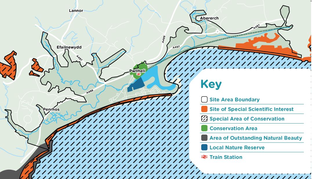
Pwllheli – the wider context
Shoreline Management Plans (SMP2s) are policy responses to environmental changes. They provide the framework for managing the long-term impact of tidal flooding across Wales.
They break the coastline down into smaller sections known as ‘policy units’ and explain how each unit should be managed in the short, medium, and long term, taking into account the sustainability of flood risk management activities and assets and priorities for flood protection.
Coastal Squeeze
Where man-made structures have been built to protect communities and land from coastal flooding and erosion, such as sea walls or rock revetments, the habitat may be prevented from moving landward as sea levels rise whilst it continues to be lost from the lower shore. This is known as ‘coastal squeeze’.
Coastal squeeze means that the saltmarsh size and function is reducing over time, along with the habitats and species that it supports.
A lot of saltmarsh habitat is legally protected therefore we are required to create new saltmarsh to offset losses in the future with sea level rise.
Livelihoods
Landowners and farmers may have noticed that the environment is changing and we want to hear your adaption concerns and ideas.
Natural Environment
The study area forms an important blend of coastal and wetland habitats that act as green corridors into surrounding countryside.
The environmental importance of this area is reflected in the large number of protected habitats and species.
Many of these are of National and International importance and these too are being threatened by the effects of flooding and climate change.
Recreation
This study area offers many opportunities for diverse recreational pastimes. These too will be carefully considered, as they are of vital importance for people’s health and wellbeing, and also bring income to the community.
Historic Environment
The area surrounding Pwllheli has a long and fascinating history. Pwllheli itself has been a settlement since the 13th Century with a strong association with the sea, having been the main fishing port of the Llyn.
The coastline here has however changed considerably over time. Over the last 150 years there has been significant human intervention and development. These actions will have affected the shoreline development during this period and will continue to do so into the future. For example, the construction of the railway enclosed the marsh areas along the east coast, and in doing so has restricted any landward movement of the dunes themselves.
There have been extensive changes to the Pwllheli South Beach, with land reclamation having taken place during the 19th century. The railway was extended across the north quay to Pwllheli in 1910, which effectively fixed the position of the shoreline at Pwllheli itself.
In 1813 the Pwllheli embankment (Embankment Road) and tidal flood gates were constructed connecting the main town with the South Beach. This created the basic structure of the inner and outer harbour that exist today as well as having a marked impact on how the land west of here has adapted.
Landscape
The outstanding natural beauty of the area with its close association with the Eryri National Park needs careful consideration when project planning.
Our work in the area
Natural Resources Wales is Wales’s largest environmental body. As well as managing flood risk, we have many legal duties and responsibilities to ensure we protect the outstanding environment we live in both now and in the future.
To achieve this, we have started carrying out a number of specialist surveys to help us understand the current state of nature.
We call this our baseline. Environment assessments will be used to ensure that all necessary approvals are in place for any work we carry out.
We must: protect the natural and historic environment, use natural resources in a sustainable way, seek ways to avert the Climate and Ecology Emergencies.
The Project
We have created a computerised flood model to calculate potential flood extents and water depths from storms. We are using this to understand the problem at Pwllheli and have carried out environmental surveys as part of evidence gathering.
We have been assessing a Long List of options to reach a proposed Short List, prioritising flood risk reduction to people and homes.
Outside the scope of the Project, but ongoing:
- We inspect, operate and maintain flood defences working with asset owners and other organisations.
- We fulfil conservation and regulatory duties to protect the environment.
- We currently maintain the three main rivers entering Pwllheli (Erch, Penrhos & Rhyd-hir)
- We issue flood alerts and flood warnings for the coast, as well as fluvial flood warnings for the Erch and the Rhyd-Hir.
- We will continue to perform our ongoing response functions during a flood.
Flood defence structures
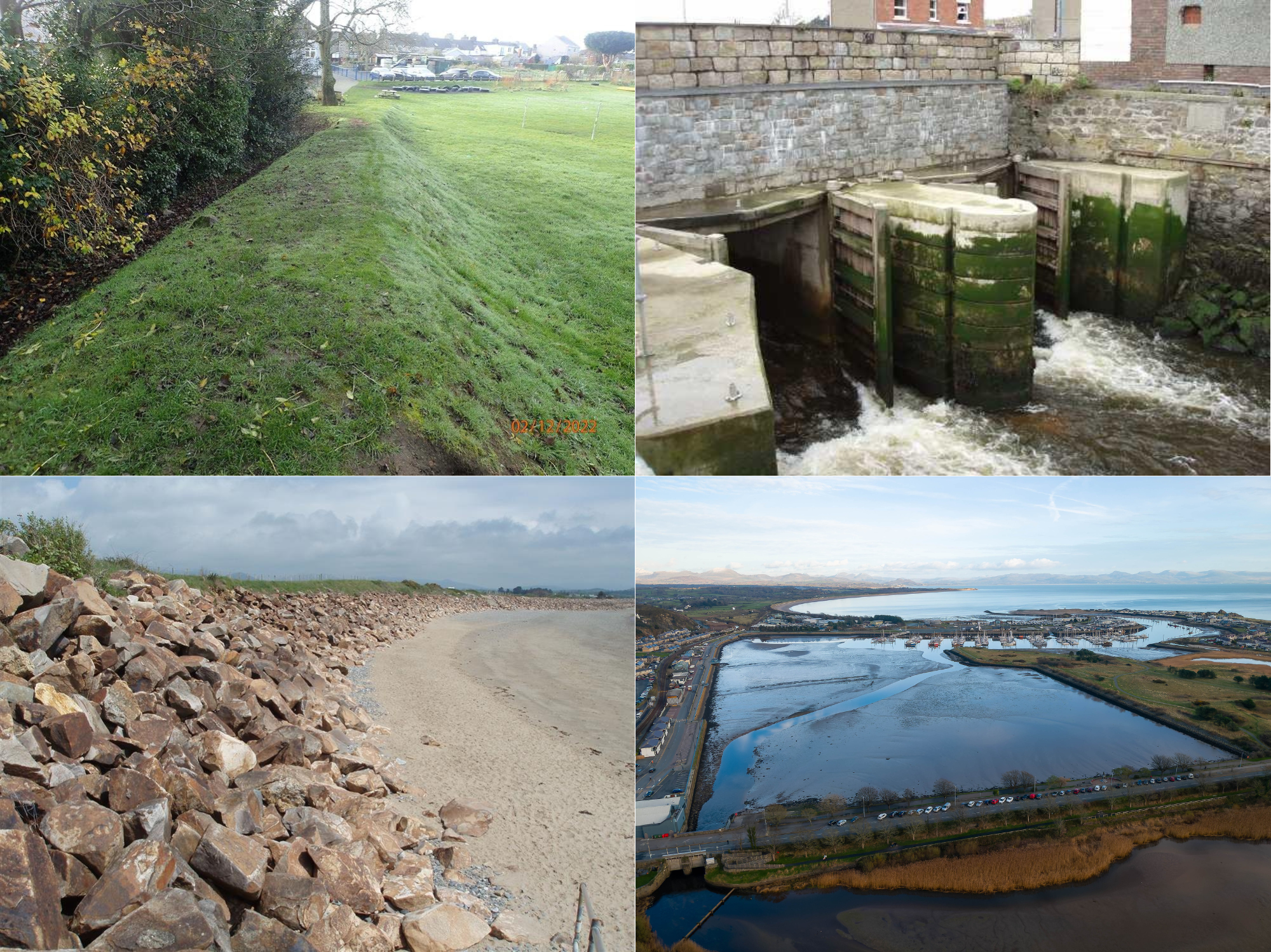
Several flood defences exist in the Pwllheli study area. These include embankments, harbour wall and mechanical gates at key locations.
Through this study, we are developing our understanding of the flood risk and the function of the defences so we can continue to protect homes and businesses in the long-term.
Coastal flood risk
Flood Risk along the coast is influenced by the coastal processes. Increased erosion is putting pressure on the existing defences, with this comes an increasing risk of breaches and consequently tidal flooding.
Holding the line in the areas of current erosional pressure increases the potential for erosion on areas either side of the protected area. Therefore, the options taken forward are focused on managing the realignment of these areas in line with the Shoreline Management Plan.
Options proposed for the shortlist:
- Raised Harbour walls - Increase defence heights around the harbour where needed to manage the risk of flooding from future storm events.
- New Harbour Gates - A regulated barrier at the harbour entrance to create capacity within the harbour to manage river flooding and equally to manage tidal flood risks from storm surges.
- Realign Defences (Inland) - New coastal defences to the west of the town, perpendicular to the coastal frontage allowing the coastline to move back.
- Realign Defences (Coastal) - New coastal defences moved marginally inland but remaining consistent with the current alignment along the western coastal frontage, allowing the coastline space to move back.
Options not proposed for the shortlist:
- Groynes and Breakwater - Hard barriers (typically rock or timber) designed to help trap sediment and preserve the beach, improving protection from flooding and erosion.
- Beach/Sand Replenishment - Introducing significant volumes of sediment or sand along the western frontage to increase the extent to which the dunes and shore can act as a barrier to storm events.
- Hard Engineering Defences - Hard engineered defences such as rock armour or rip-rap to protect the shoreline against scour and wave erosion.
Flood risk from rivers – West
There are several watercourses and areas of interest to the west of Pwllheli. Here three main rivers the Afon Rhyd-hir, the Afon Penhros and Afon Ddwyryd merge as they approach the western edge of Pwllheli. They continue towards the town as the Afon Rhyd-hir which enters the harbour through tidal gates below Embankment Road.
Flood risk from these watercourses primarily arises from the rivers becoming “tide-locked” when the gates close during high tides. When this coincides with high river flows from prolonged or heavy rainfall, water levels in the rivers increase, overflowing into the surrounding floodplain. This can result in flooding to people, property and the A499.
Options proposed for the shortlist:
- New Harbour Gates - A regulated barrier at the harbour entrance to create capacity within the harbour to manage river flooding and equally to manage tidal flood risks from storm surges.
- River Diversion - A reprofiling of the gradient to diverts flows to the coast at a new location west of the town.
Options not proposed for the shortlist:
- Upstream Storage - Introducing changes in the upstream land to create greater capacity for flood water to be stored there.
- Overpumping on the Afon Rhyd-hir and Afon Penrhos - High volume pumping stations to be constructed in Pwllheli, designed to pump high river flows to the sea when high tides would otherwise cause a backing up effect.
- New Flood Defences - Localised defences within the town centre where they can provide direct protection from river flooding.
These are additional options that will be taken forward for consideration in conjunction with the main options that are shortlisted.
- Dredging - Significant ongoing dredging and channel reprofiling of the rivers to improve flows and capacity.
- Localised Road Raising - Increasing the height of the roads above predicted flood levels to lessen risk of road closures through flooding.
- Natural Flood Management - when natural processes are used to reduce the risk of flooding through restoring bends in rivers, changing the speed water flows in rivers and the way land is managed so soil can absorb more water.
- Property Flood Resilience - measures that can help to prevent flood water ingress into a building or aid rapid recovery following a flood event.
View the information board for Flood risk from rivers - West
Flood risk from rivers – East
To the east of Pwllheli the Afon Erch flows from Abererch village towards the town. This river enters the harbour on its eastern side, after passing through the tidal gates adjacent to Abererch Road.The main area of flood risk from the Afon Erch is within Abererch village.
There are existing flood defence structures here including an embankment which helps to protect the village. However, there remains a flood risk from over topping of the banks in extreme events which could become more frequent with climate change.
Options proposed for the shortlist:
- Direct Defences (Flood Walls/ Embankments) - Raised flood defences in Abererch providing a direct line of defence against flooding from the Afon Erch.
Options not proposed for the shortlist:
- Upstream Storage - Introducing changes in the land upstream, north of Abererch tocreate capacity for flood water to be stored there.
These are additional options that will be taken forward for consideration in conjunction with the main options that are shortlisted.
- Dredging - Significant ongoing dredging and channel re-profiling of the Afon Erch to improve flows and capacity.
- Natural Flood Management - when natural processes are used to reduce the risk of flooding through restoring bends in rivers, changing the speed water flows in rivers and the way land is managed so soil can absorb more water.
- Property Flood Resilience - measures that can help to prevent flood water ingress into a building or aid rapid recovery following a flood event.
View the information board for Flood risk from rivers – East
Appraising the options
Critical Success Factors
These are the project outcomes that are crucial to the successful delivery of the project and differ from the Objectives which identify aspirational outcomes.
Strategic Fit and Business Needs - The option should substantially reduce flood risk from sea and main rivers. It should align with the relevant flood risk management strategies, policies, guidance and deliver wider benefits to the locality.
Potential Value for Money - The option should achieve a positive cost benefit ratio. It should deliver efficiencies and minimise costs associated with future maintenance and operational requirements.
Supplier Capacity and Capability - The option must match the capacity and capability of potential suppliers to deliver it.
Potential Affordability - The option must meet the requirements and deliver outcomes to be eligible for funding via Welsh Government Flood Risk Management Grant in Aid. The option should consider opportunities to provide benefits to potential funding partners.
Potential Achievability - The option must be physically possible to construct within the constraints in the area. The relevant consents and permissions must be securable. The Risk Management Authority must be able to meet the long-term management and maintenance needs of the option.
Investment Objectives
The project investment objectives have been established through early dialogue with stakeholders and are presented in the following table. These investment objectives are aspirational and set out ‘where we want be’ or ‘what we want to achieve’ and are not so narrowly defined so that they set limits on what is possible.
- Anticipate the effects of climate change and seek to reduce the flood risk and impact to properties, transport infrastructure and risk to life associated with fluvial and tidal flooding from the Erch, Rhyd-hir and overtopping and breaching of Pwllheli’s Coastal frontage.
- Increase performance of the existing flood defences and control structures, including reducing the short to long-term operational maintenance and health and safety liabilities.
- Understand evolution of coastal processes and the timeframe and trigger points for SMP policy implementation. Put forward solutions that will deliver against the SMP2 policies for the various Pwllheli frontage sections that will be adaptable to wider strategies set out by NRW and Cyngor Gwynedd.
- Seek to deliver a flood risk solutions that can demonstrate delivery against SMNR principles and benefits. Supporting Welsh Government climate and biodiversity emergency priorities.
- Seek to maintain and enhance biodiversity and ecosystem resilience, through working with Natural Flood Management and identifying wider opportunities in the catchment.
- Through effective engagement consider the needs and views of the local community and stakeholders.
- Seek to support amenity and regeneration in Pwllheli and where possible enhance, natural, historic, visual and built environments in order to support local culture and the Welsh language.
- Seek to promote sustainable management of the dunes (a priority habitat), whilst improving access and improving social and recreational cohesion.
- Identify options within a ‘Coastal Adaptation Plan’ for habitat creation, restoration and enhancement in support of Sustainable Management of Natural Resources (SMNR) and conservation priorities.
- In conjunction with the public and stakeholders, support the planning and communication of a ‘Coastal Adaption Plan’ for the western and eastern Pwllheli coastal flood plain.
Shortlist Option Combinations
There are multiple areas of flood risk in the study area that require mitigation from both fluvial and coastal sources. Therefore, the location specific options have been joined to create a shortlist of compatible options that cover the whole study area.
The proposed combinations may be subject to change pending the final results of the Strategic Outline Case (SOC) assessment.
Combination A:
- Rivers West - Business as usual
- Coastal West - Managed realignment (coastal)
- Harbour / Central - New harbour gate
- Rivers East - New flood walls / Upgrade existing assets
- Coastal East - No active intervention
Combination B:
- Rivers West - River diversion
- Coastal West - Managed realignment (coastal)
- Harbour / Central - Raised harbour walls
- Rivers East - New flood walls / Upgrade existing assets
- Coastal East - No active intervention
Combination C:
- Rivers West - Business as usual
- Coastal West - Managed realignment (inland)
- Harbour / Central - New harbour gate
- Rivers East - New flood walls / Upgrade existing assets
- Coastal East - No active intervention
Combination D:
- Rivers West - River diversion
- Coastal West - Managed realignment (inland)
- Harbour / Central - Raised harbour walls
- Rivers East - New flood walls / Upgrade existing assets
- Coastal East - No active intervention
View the information board for Shortlist Option Combinations
Areas
- Pwllheli North
- Pwllheli South
Audiences
- Flooding
Interests
- Flooding
Share
Share on Twitter Share on Facebook