Borth to Ynyshir Coastal Adaptation Project
Overview
Darllenwch y dudalen hon yn Gymraeg | Read this page in Welsh
Feedback survey
Thank you to those who attended our Borth to Ynyshir Coastal Adaptation (BYCA) project drop-in event on Saturday 21 February 2026.
We had lots of useful and interesting discussions which we will take into consideration when starting the development of this 100+ year strategy.
For those who were unable to attend, we would still like to hear from you – complete a feedback form by 14 March 2026.
All exhibition boards shared during the public drop-in event can be viewed below. Other materials from the consultation are available at the bottom of this page.
Newsletter sign-up
Use this link to sign up to recieve our newsletter, and information on upcoming events and news.
Here's a copy of our most recent newsletter:
Your browser does not support inline PDF viewing. Please download the PDF.
What is this project about?
Climate change and sea level rise will have a significant impact on future flooding in Wales. The standards of protection afforded by coastal infrastructure are reducing, and we must consider the future costs and sustainability of current alignments and standards of protection.
Natural Resources Wales (NRW) and Ceredigion County Council (CCC) are committed to working together to manage future flood risk and are seeking to develop a sustainable plan which highlights interventions that could be undertaken depending on the level of sea level rise observed over 100+ years.
The Borth to Ynyshir Coastal Adaptation Project is starting to explore a range of possible options going forward. We seek to engage with community members to understand their views and to gather insights from their diverse experiences to inform future planning.
This project forms part of NRW’s wider Coastal Adaptation Programme, designed to work with Risk Management Authorities (such as local authorities) in planning for and funding long-term resilience in areas vulnerable to flooding and coastal change.
Watch this video to learn more about the Borth to Ynyshir Coastal Adaptation (BYCA) Project. It is a recording of a webinar hosted by the project team held in February 2026 during the initial consultation stage.
Who is Natural Resources Wales?
As Wales’ largest Welsh Government Sponsored Body, we work for the people of Wales, and it is our duty to pursue the sustainable management of natural resources (SMNR).
These guiding principles underpin everything we do, including how we use our connections and bring people together to create and deliver shared outcomes for nature and climate. They inform how our colleagues flex and respond to the diverse needs of our communities and the environment, taking a place-focussed approach to our work, applying the sustainable development principle and contributing to the seven well-being goals set out in the Well-being of Future Generations (Wales) Act 2015.
Managing flood risk, coastal change and the sustainable adaptation of people and nature are key parts of that effort. We also manage designated sites within Wales and advise on environmental impacts of development.
Who is Ceredigion County Council?
Ceredigion County Council is the Lead Local Flood Authority, responsible for managing both inland and coastal flood risks across the county. Inland, it oversees surface water, groundwater, and ordinary watercourse flooding, while on the coast it helps maintain sea defences, manage coastal erosion, and deliver protection schemes in partnership with Natural Resources Wales and Welsh Government. The council also develops local flood risk strategies, supports sustainable drainage (SuDS) in new developments, and coordinates emergency planning and community resilience efforts for all types of flooding.
Location
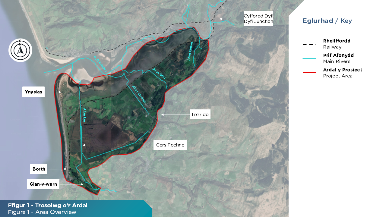
To help assess flood risk and consider future management approaches, we have divided the project area into four compartments (A-D). Each compartment is defined by the boundary of one of the main rivers, (Afon Leri, Afon Clettwr and Afon Ddu).
What is the problem?
Like many coastal communities, this area is facing the combined challenges of rising sea levels, more frequent extreme storms and deteriorating assets as a result of climate change. These changing conditions are placing growing pressure on existing flood defences and increasing the risk of flooding.
Managing flood risk for people, homes, and infrastructure is a key priority for us which is becoming more challeging in a low-lying landscape with ageing defences, many of which have been breached in recent years.
This issue is shared by partner organisations, stakeholders, landowners and the local community. Sustainable options for managing flood protection and adaptation will be developed through consultation and based on clear evidence and sustainable approaches to managing this challenge.
For the Borth to Ynyshir project area, Welsh Government forecasts a sea level rise of approximately one metre over the next 100 years, based on the UK Climate Projections 2018 RCP8.5 scenario (developed as part of the Met Office Climate Centre).
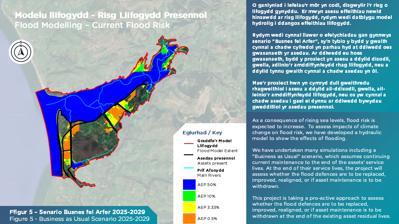
To understand the impacts of sea level rise, changing weather, and tidal patterns, we have developed a hydraulic model and have undertaken various simulations to calculate current and future flood extents. We have set a baseline scenario as a basis to assess any change in management against. These baseline simulations are referred to as the “Business As Usual Scenario (BAU)” which assumes that existing ongoing maintenance activities are undertaken until the end of the current flood asset lives, and that no further flood risk management approaches will be undertaken thereafter.
The Business As Usual Scenario has been assessed for four time periods (years 2025-2029, 2030-2054, 2055-2074 and 2075-2125).
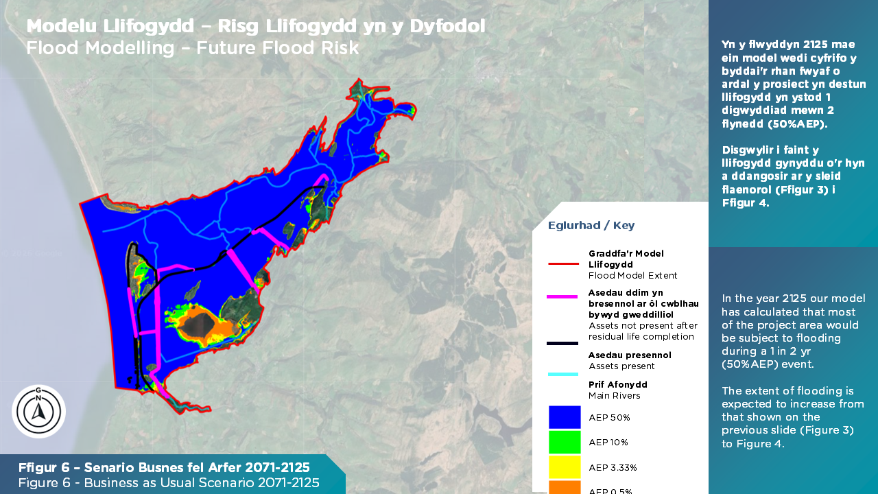
Our assessments show that a number of existing flood risk management assets are predicted to breach more frequently over the next 100 years.
Our model simulations also show (see figure below) that due to low land levels, much of the project area would be subjected to tidal and fluvial flooding (rivers overtopping their banks) during a 1 in 2 yr (50% AEP) storm scenario by 2125. Flood extents are expected to increase gradually between the present day to the year 2125.
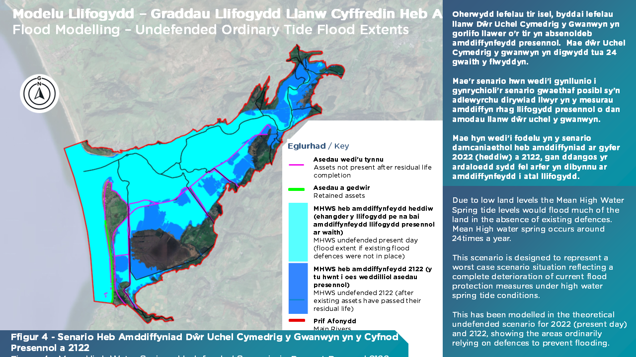
We have also assessed an undefended model scenario with a Mean High Water Springs tide in the present day (2022), and 2122 (Figure 4).
This scenario assumes that the flood assets (tidal river and estuary banks, with the exception of the coastal frontage) are removed. Whilst this is a theortical scenario (as the watercourses and estuary are currently defended) it demonstrates the impact of the removal of defences on possible future flood extents.
The figures below (5 and 6) provide a useful understanding of the flood risk and the scale of the future challenge. We will use this to develop flood risk management options and approaches to support communities in the future.
How are we seeking to address the problem?
To respond to this challenge, NRW and CCC are aiming to produce an “Adaptive Management Plan”. This is a plan which provides a roadmap with multiple interventions depending on the level of sea level rise observed and the level of protection provided by assets. The sequence of options over the next 100 years will be implemented based on observed sea levels and protection provided by assets are known as ‘adaptive pathways’.
Instead of committing to one fixed solution, an adaptive pathway identifies decision points, often triggered by factors such as observing rising sea levels or increased flood frequency. These decision points allow us to make more informed decisions based on observed data rather than predicted data. This creates a flexible long-term strategy that allows investment to be timed appropriately and ensures the project can respond to future uncertainty. This Adaptive Management Plan will be developed through collaborative working between NRW, CCC, and local and national stakeholders such as those within the water and transport sector.
As part of this project, we will look at opportunities minimise impact and best adapt to the increasing flood risk to this unique and special landscape, e.g. Cors Fochno, Ynyshir Nature Reserve, Ynyslas Dunes. We will explore the wider benefits of amenity, the beach, tourism, and visual landscape, as well as local ecology.
A wide range of suggested adaptation management approaches are currently under development – these overarching approaches will be shared as part of the Spring 2026 Public Consultation.
Whilst we develop this Adaptative Management Plan, NRW and CCC are continuing with our routine day-to-day coastline (CCC) and inland (NRW) flood management, flood warning, and maintenance works.
We will update this page with new information as the project moves forward and you can view previous materials at the bottom of this page.
Project Objectives
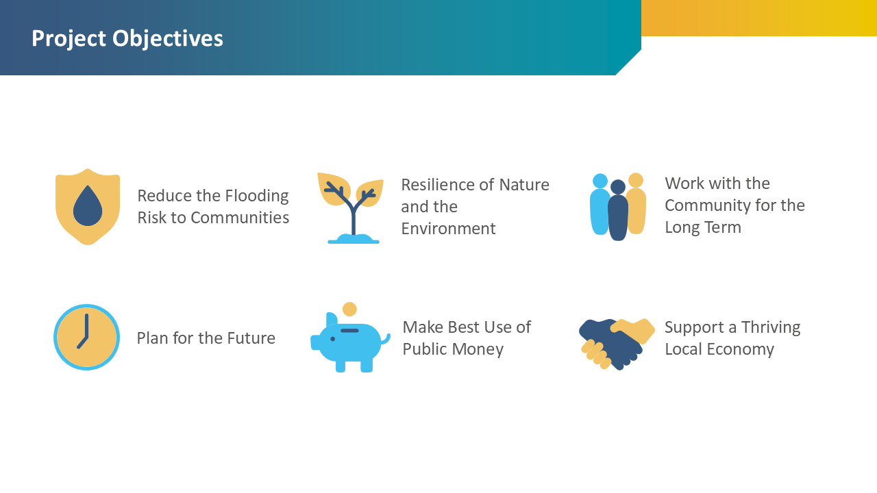
The project objectives are summarised above.
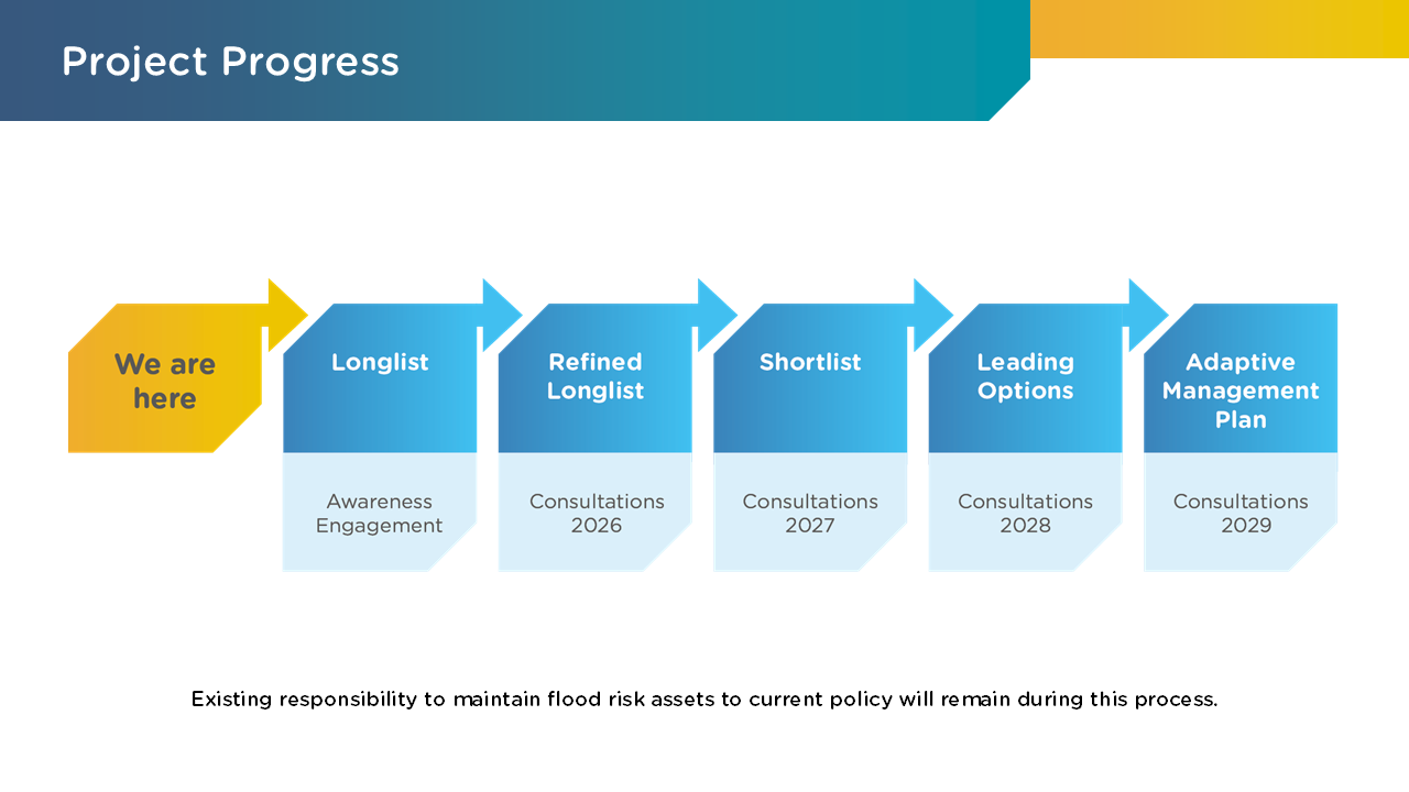
Project Stages
This project will appraise flood risk management options in accordance with the HM Treasury Green Book. This guidance defines the process of drafting, developing and assessing options, ultimately reaching a preferred option (or an adaptive pathway for this project). The process is split into a number of stages, which comprise of:
- Drafting a long list of options (and ensuring no option is excluded)
- Refining the long list of options to a short list of options, where options that cannot feasibly be progressed are ruled out
- Undertaking detailed assessments to identify the preferred option.
We want to develop this project alongside the affected communities and relevant stakeholders during each stage of the project. There will be a number of rounds of public consultation to ensure that lived experiences from the community inform the strategies.
Stage 1 Consultation Materials
This is a library of the promotional products used to promote the project to the local community and stakeholders.
Exhibition Boards:
Newsletter:
Poster:
Some key technical terms that will be useful
Return period - A return period tells us, on average, how often a flood of a certain size might occur. For example, a 1 in 100 year flood has a return period of 100 years. This does not mean it happens only once every 100 years, it means that each year there is a 1% chance of a flood that big (or bigger) occurring. A shorter return period means floods are more frequent.
Coastal flooding - Coastal flooding is when the sea inundates coastal areas that are normally dry, causing damage to homes, roads, and ecosystems. It can happen due to a combination of factors such as storm surges, high tides and sea level rise. For this project this is used to identify flooding directly form the sea due to the waves and water levels.
Tidal flooding is also a form of coastal flooding, though on this project it is being used to refer to flooding from the estuary due to high tidal water levels.
Fluvial Flooding – Fluvial flooding occurs when rivers get too full, usually after heavy rain (which may occur higher up in the catchment), snowmelt, or upstream water flow, and the water spills into nearby towns, fields, or roads.
Pluvial Flooding - Pluvial flooding occurs when intense rain overwhelms drainage and floods streets, homes, or land. Pluvial flooding is caused by surface water runoff (rain) rather than flooding from rivers or sea.
Groundwater Flooding - Groundwater flooding is the emergence of groundwater (water table) at the ground surface separate to water from the river or the sea.
Flood Defence Assets - A flood defence asset is any structure or feature designed to protect people, property, and land from flooding. This can include things like walls, embankments, or barriers that block or control water. These assets help reduce the risk and impact of floods, keeping communities safer.
Consultation Programme
We are currently undertaking initial consultation with relevant stakeholders to introduce, and gain feedback on the project objectives. Throughout this consultation period we want to understand your experiences of flooding (which may include photo and video records), your priorities and how you would like to work together with us to inform the development of this plan. During the appraisal process we will be forming a number of working groups with stakeholders; during the initial consultation we’re keen to understand which stakeholders should represent the community.
We recognise that the success of the Adaptation Management Plan is dependent on collaborative working between NRW, CCC and the local community.
This initial round of consultation will be followed by a Public Consultation on the Longlist Options (currently under development) in Summer 2026. Prior to this public consultation, we will be hosting a number of Stakeholder Engagement Sessions with local Community Councils, and a Public Drop-In Session.
Details of the consultation programme can be found below:
|
January and February 2026 |
Stakeholder Engagement Sessions with Community Councils and Elected Officials |
|
February 2026 |
Public Drop-In Sessions |
|
Summer 2026 |
Public Consultation on Longlist Options |
There will be future consultation to confirm the longlist options in project compartments, short listed options and preferred option(s) within more specific areas of the project.
Areas
- Borth
- Ynyshir
Audiences
- Flooding
Interests
- Flooding
Share
Share on Twitter Share on Facebook