
Kenson River Restoration
Overview
Click to read this page in Welsh / Cliciwch i ddarllen y dudalen hon yn Gymraeg
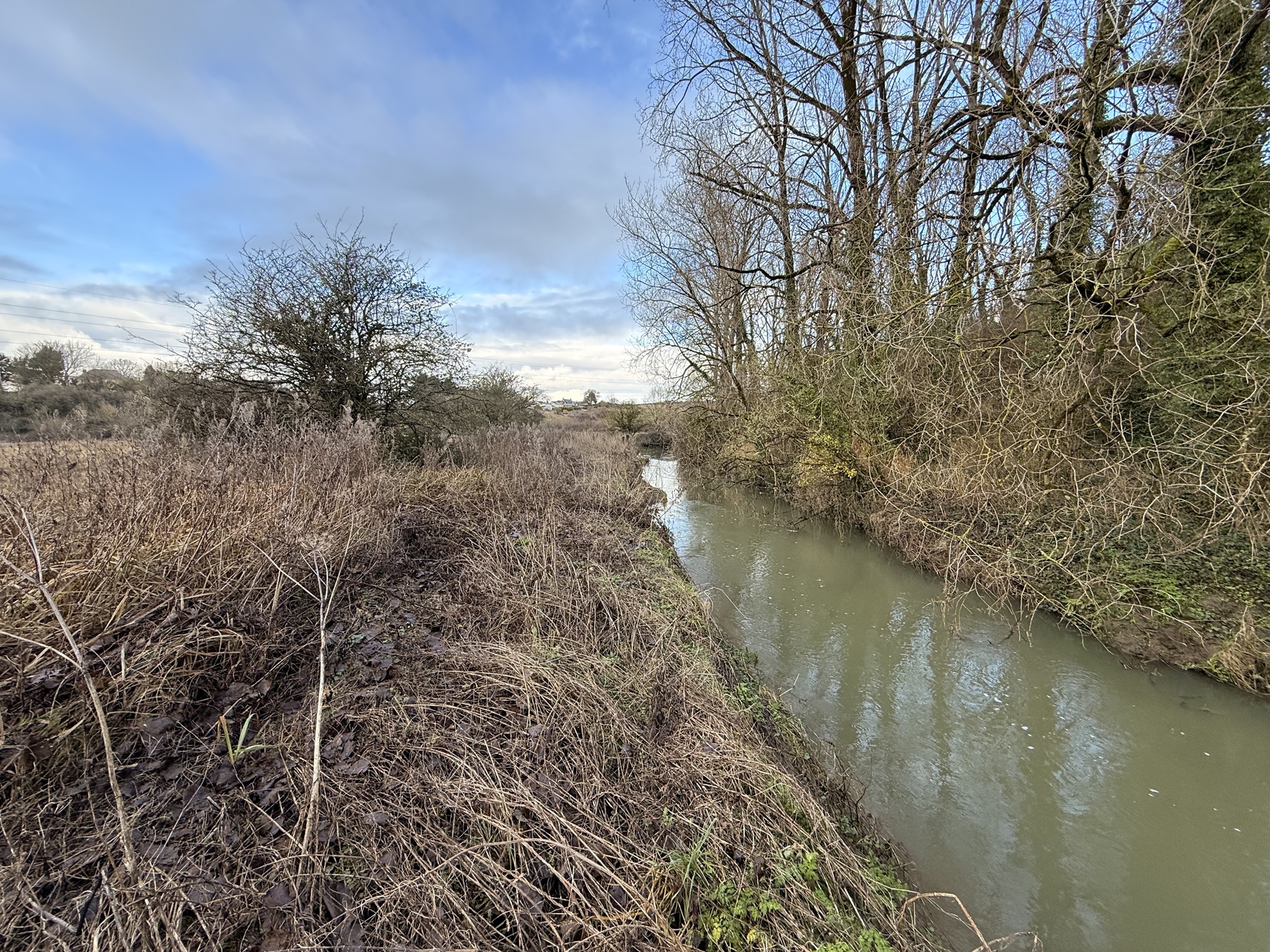
Natural Resources Wales is working with Fonmon Castle to restore a section of the Kenson River in the valley of the Fonmon Estate near Rhoose in the Vale of Glamorgan.
The Kenson River is a small watercourse that flows through the Vale of Glamorgan, eventually joining the River Thaw before reaching the Bristol Channel. Historically, the river supported a rich mosaic of habitats, including wet meadows and riparian woodland, which provided refuge for wildlife and helped regulate natural flooding. Over time, agricultural intensification and channel modifications have altered its character, reducing habitat diversity and disconnecting the river from its floodplain. Despite these changes, the river remains an important feature of the local landscape and a key contributor to the area’s ecological network.
The Kenson River currently fails to meet Good Ecological Status under the Water Framework Directive (WFD) Regulations, primarily due to pollution from rural diffuse pollution, fine sediment input, limited channel features and flow diversity, poor floodplain connectivity, and impacts on fish migration.
The river’s natural meanders were removed during channel realignment works in the 1950s, resulting in an artificially straight, uniform, and overly deep channel with minimal variation in form and habitat. Historical channel depressions are however still present in the fields of the valley, demonstrating that flows previously migrated across a larger area of the floodplain.
The Kenson River restoration project aims to restore 2.5km of natural river processes by reinstating the natural meander and course of the river. This will also add 450m of diverse habitat for fish, such as eels and sea trout, otters, water voles, invertebrates and aquatic plants.
The restoration targets achieving ‘Good Ecological Status’ by improving water quality, habitat diversity, and sediment transport. It will contribute to a resilient ecosystem to climate change challenges, such as flooding and drought.
The project also aims to reconnect the community with their local river by restoring a healthy, functioning ecosystem where both people and nature can thrive together.
Project Update
The project team has been working with landowners, local communities, and other stakeholders to prepare for the river restoration works starting this summer.
Planning permission is currently being considered by the Vale of Glamorgan Council, with a decision expected in September 2026. To access the planning documents please visit the Vale of Glamorgan Planning Register.
The delivery of the works has been split into two phases to deliver over this summer 2026 and summer 2027:
Plan for Phase 1: Summer 2026
- Installing woody material within the river channel in Reaches 2, 5 and 6 to improve habitat diversity and natural river processes
- River corridor tree planting on the right bank of Reach 1 near Kenson Hill Road Bridge (Winter 2026)
- If the planning permission is granted with enough time remaining for this year’s construction window we will also regrade the riverbank and remove embankments in downstream Reaches 5 and 6 near the B4265 for improved floodplain connectivity. Some of this material will be used to block the culverts of two of the drainage ditches to reduce floodplain drainage into the River Kenson
Further updates will be provided as the project progresses.
Project benefits
The aim of the project is to bring the river into ‘Good Ecological Status’ by restoring 2.5km of the river, and the re-meandering will result in an extension of up to 450m to the river channel.
Returning to the historical planform will restore natural geomorphological processes, such as the transportation and deposition of materials.
The 450m of increased river length will provide additional habitat for species such as critically endangered European eels, water voles and invertebrates. In turn this will contribute to a diverse and resilient habitat. The improvements in habitat quality and quantity will further support rewilding efforts underway at Fonmon Estate.
The increase in channel length and naturalised channel sinuosity will enhance habitat quality within this lower stretch of the river. While spawning opportunities here are mainly limited to species such as stickleback and bullhead, the improved channel form will support the upstream migration of fish, including eels, lamprey and trout, by providing increased cover and more varied habitat. These enhancements will offer wider ecological benefits beyond the project boundary and upstream towards the failing WFD Llancarfan waterbody, including improved conditions for juvenile fish such as eels.
The project will provide increased floodplain connectivity over 20 hectares. This means:
- Increased flood capacity within the valley.
- Slower water flow during flood events, with water spilling into the floodplain. This allows sediment to settle and infiltrate. The wetland habitat acts as a purifier, which improves water quality downstream.
- New ponds and meanders slowing water flow also act as refuge for species, which would otherwise be washed away by faster flowing water.
Design Features
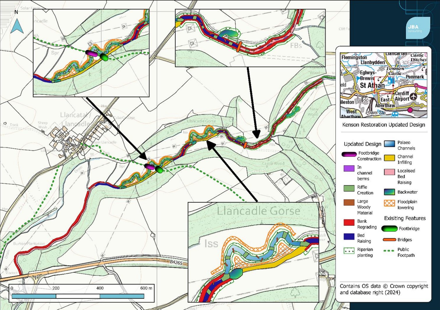
Project visuals
Upstream
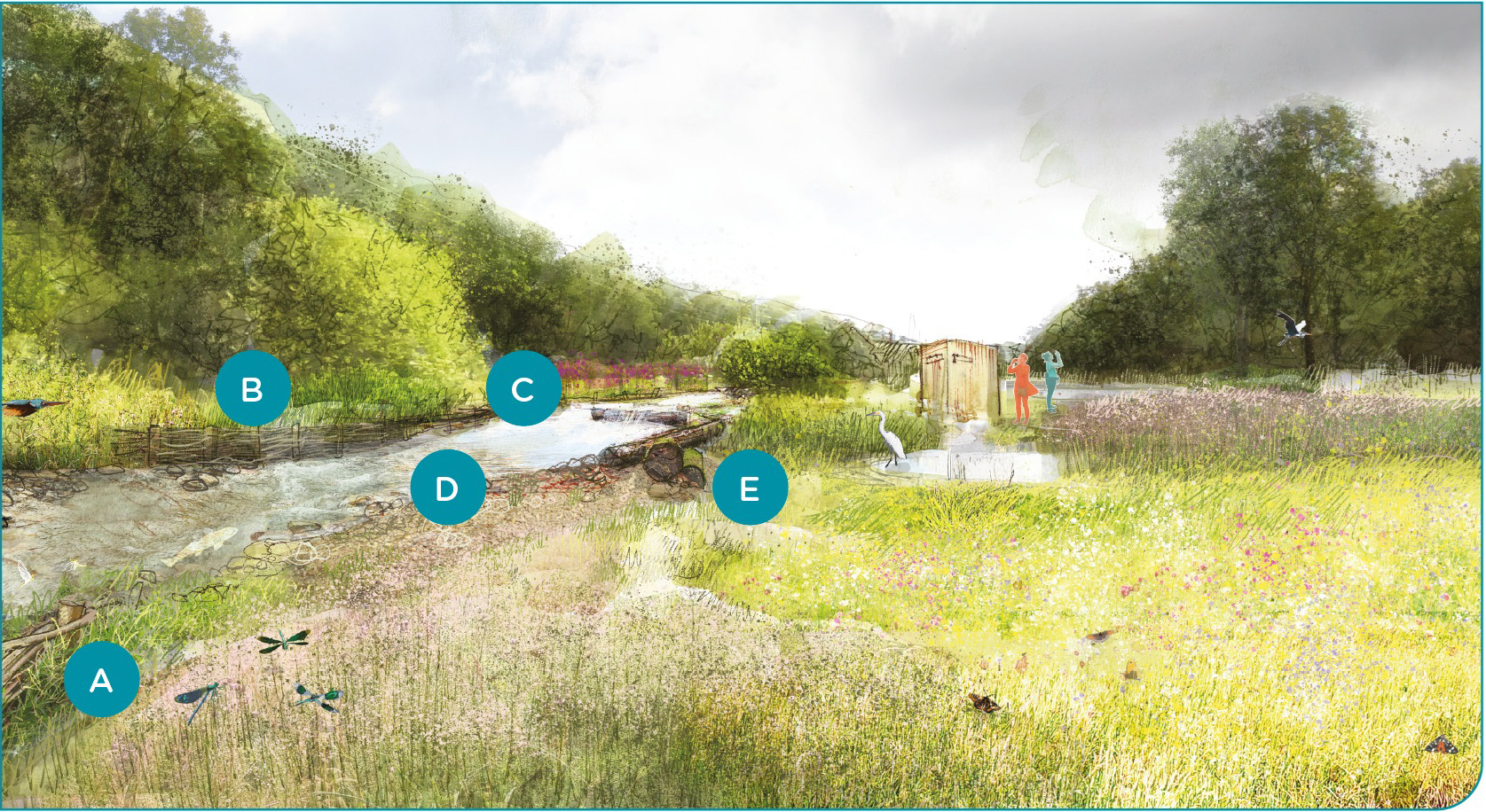
A - Creation of berms made with brashy/woody material and willow spiling
B - Embankment removal and regraded banks
C - Riverbank planting with native species
D - Gravel/sediment introduction to create natural undulations in riverbed
E - Introduction of woody material/large wood
Downstream
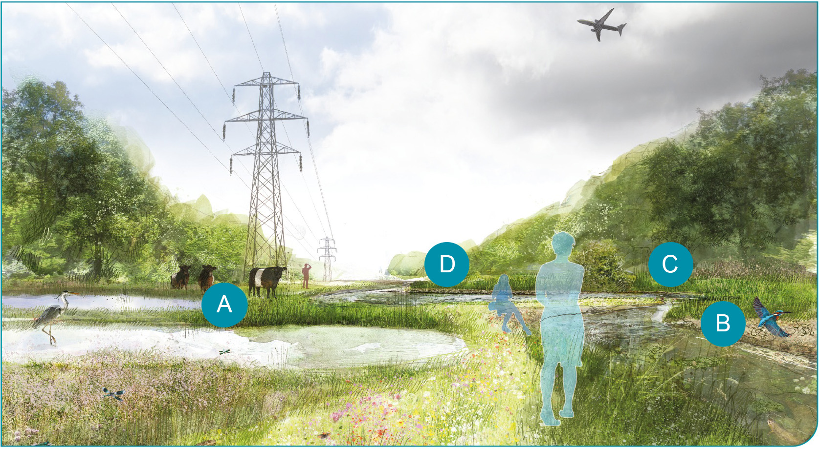
A - Conservation Grazing
B - Embankment removal and regraded banks
C - Riverbank planting with native species
D - Improved connection to floodplain, reconnected historical channels and natural meanders
Flood modelling
Detailed flood modelling of the River Kenson was carried out to understand how the area floods now and how it might change after the planned river restoration works.
The results show that the site floods in all scenarios - both before and after the restoration - which is what was expected (given that the site is an existing floodplain).
Flooding is generally deepest in the southern part of the site and shallower in the north.
After the restoration, the modelling shows small but noticeable improvements in some places. Some areas outside the restored river corridor will see slightly less flooding, both in terms of flood depth and how far the water spreads. No areas outside of the scheme shall be adversely affected by an increase in flood risk.
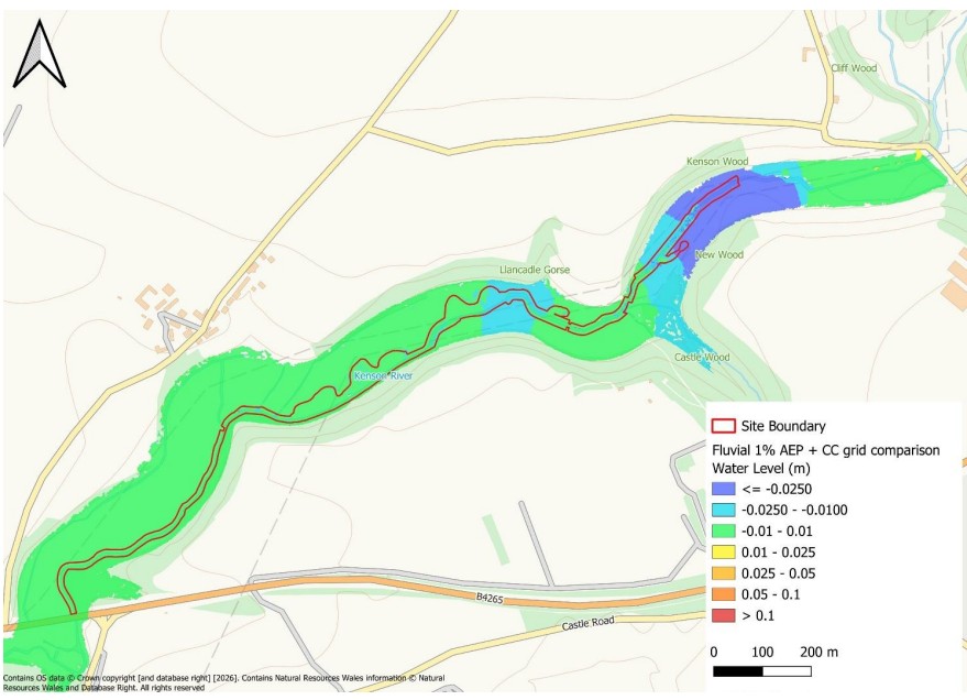 Fluvial 1% AEP plus Climate Change Post-Development Grid Comparison
We tested the project using a major flood scenario often called a 1% Annual Exceedance Probability (AEP) or 1 in 100-year flood event. This means there is a 1% chance of such a flood happening in any given year. It does not mean it only happens once every 100 years.
In this large flood scenario, the modelling shows that the proposed restoration reduces the maximum water levels across the site and the surrounding floodplain when compared to the baseline levels:
- Up to 5 cm lower water levels in the north‑east area of the site (dark blue areas)
- Less than 1 cm reduction in the south‑west (green areas)
These small reductions occur because the river channel will be widened, allowing it to hold and move more water during high flows. This extra capacity creates modest but measurable local benefits compared with the current situation.
More detailed flood modelling results are included in the Pre-application consultation documents.
Will the project increase flood risk to upstream communities?
No. The restoration work will not increase flood risk to homes in Llancarfan or other upstream communities.
Our flood modelling shows that the effects of the project are limited to the area where the physical river restoration works will take place, downstream of Penmark.
Our hydraulic model of the Kenson river covers the proposed river restoration site and upstream to the Kenson Hill road bridge. This location was chosen as the bridge acts as a control point for the river, limiting the potential impact from the river restoration work to upstream. This structure forms a hydraulic feature beyond which effects from the scheme are very unlikely to pass upstream; such locations are typically used to set model extents. Further to this, the flood modelling shows no increase in water levels at the upstream extent of the scheme. We therefore found no evidence that the model needed to be extended further upstream.
The approach used for the flood modelling of the study area and appraising the effectiveness and impacts of the scheme was developed in conjunction with NRW’s Flood Risk Analysis team and NRW consultants (JBA). This gave careful regard to the existing national scale modelling of the catchment, catchment characteristics, mechanisms of flooding and potential effects of the scheme.
The modelling results confirm that:
- The proposed river restoration scheme only has local impacts, it has no influence to upstream flood risk of the Nant Llancarfan.
- Flood levels do not change at the upstream end of the model, even during large flood events.
- There is no effect on water levels or flood behaviour in the Nant Llancarfan or other upstream areas/ waterbodies.
- The Llancarfan Village Hall is 4 metres higher than the maximum water level at the river restoration site in the 0.1% chance flood event, so houses in the village are well above predicted flood levels at the restoration site.
Flood event from rivers and surface water:
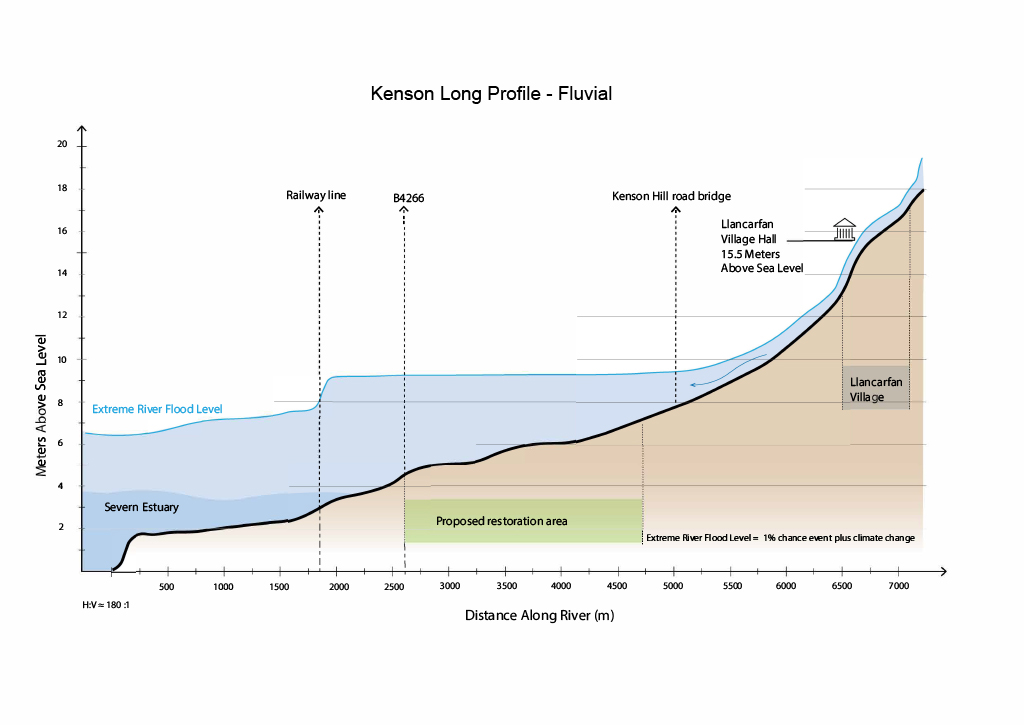
View the PDF version of the fluvial graphic
What this graphic shows
- The graphic shows the River Kenson from the Severn Estuary to a point upstream of Llancarfan village, a distance of more than 7 km / 4.4 miles.
- It shows the riverbed level and the predicted water levels during an extreme river flood event.
- This includes river flooding caused by heavy rainfall, where water levels in rivers and streams rise and overflow onto the floodplain.
- Riverbed and water levels are based on NRW survey data (LiDAR) and flood modelling of an extreme flood event.
- Locations of key bridges and Llancarfan Village Hall are shown for reference.
- The vertical and horizontal scales are different to make the profile easier to see. This means the river appears steeper than it is in reality.
What the water levels represent
- The water levels shown are for an extreme river flood event.
- They include the expected effects of climate change on future flood levels.
- The illustration shows how flood water is expected to move through the river and floodplain under these conditions.
What does this mean?
- During an extreme river flood, the railway culvert restricts the flow of water downstream, causing water levels to back up and rise within the restoration area and flood the surrounding floodplain. This effect does not extend as far upstream as Kenson Hill Road Bridge or Llancarfan village, as these are upstream of the affected area.
- The proposed river restoration works will have very little effect on water levels, and these effects only occur within the project area.
- Flood modelling of the project shows that the proposed river restoration works will not increase flooding within or outside the project area.
- They do not influence water levels or flood behaviour in the Nant Llancarfan or any other upstream watercourses.
Tidal flood event:
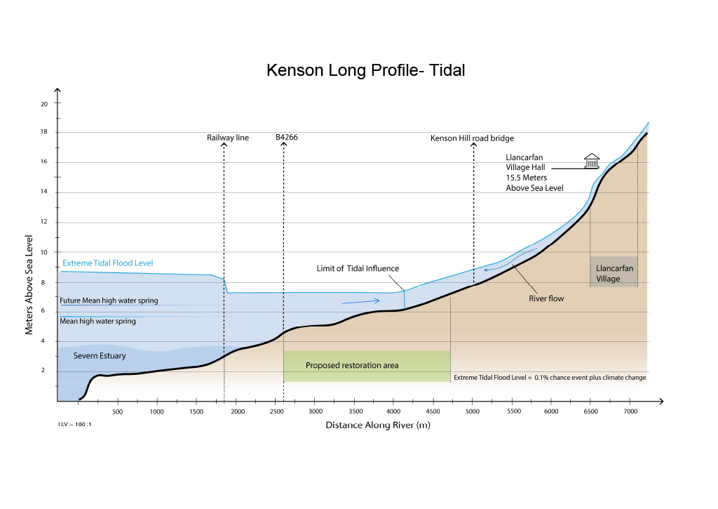
View the PDF version of the tidal graphic
What this graphic shows
- The graphic shows the River Kenson from the Severn Estuary to a point upstream of Llancarfan village, a distance of more than 7 km / 4.4 miles.
- It shows the riverbed level and the predicted water levels during an extreme high tide.
- Riverbed and water levels are based on NRW survey data (LiDAR) and flood modelling of an extreme high tide.
- Locations of key bridges and Llancarfan Village Hall are shown for reference.
- The vertical and horizontal scales are different to make the profile easier to see. This means the river appears steeper than it is in reality.
What the water levels represent
- The water levels shown are for an extreme tidal surge.
- They include an allowance for future sea level rise.
- Upstream of the tidal limit, water levels are affected by river flows rather than the tide.
What does this mean?
- During an extreme tidal surge, water levels can be affected as far as 4.5 km upstream.
- The railway embankment restricts tidal water moving further upstream.
- The proposed river restoration works will have very little effect on water levels, and these effects only occur within the project area.
- Flood modelling of the river restoration project shows that water levels are expected to be slightly lower across most of the project area during floods. In one small area near the new channel, water levels could increase by up to 5 cm. Flooding outside the project area is not expected to change.
- Even during an extreme tidal surge, water levels upstream at Kenson Hill Road Bridge and Llancarfan village are not affected due to their higher elevation.
- They do not affect water levels or flood behaviour in the Nant Llancarfan or any other upstream watercourses.
Why are healthy floodplains important?
Rivers and streams extend far beyond the narrow channels we usually picture. Their banks and the areas that flood during high water are also part of the river system. These areas are called floodplains and are important for both people and wildlife.
Over the past 200 years, human activity has significantly altered and degraded up to 90% of floodplains in the UK. Land drainage, engineered flood defences, river straightening and dredging, wetland loss, and expanding towns and farmland have damaged these vital ecosystems and reduced their natural functions.
Degraded floodplains are less able to store water and carbon, filter pollution, and support biodiversity.
Although these historic modifications have brought economic benefits and improved protection for some communities, they have also disconnected many rivers from their floodplains, reducing their critical roles in managing floods and droughts, providing habitats, and maintaining good water quality.
Today, we face more frequent and intense weather events as our climate changes, yet many of the natural benefits that floodplains once provided have been lost. Restoring floodplains through river restoration and nature-based solutions can help bring these benefits back. Reconnecting rivers with their floodplains can reduce flood risk, improve water quality, capture carbon, and create healthier habitats for people and nature.
Frequently Asked Questions and next steps
How is the project funded?
The project is funded by the Welsh Government Nature and Climate Emergency (NaCE) Capital Programme. The programme supports a number of environmental priorities including peatland restoration, metal mine remediation, fisheries, water quality and national forests.
What are the challenges or potential risks of the work?
The construction works and new features have the potential to impact trees in the river channel, however measures will be taken to limit and mitigate the impacts. Any disturbance to terrestrial and already established wetland habitats will be minimised through targeted species surveys, project oversight, mitigation and monitoring. In-channel disturbance during construction will be reduced using appropriate methods and timing.
Did the 1% AEP allow for tidal impacts?
Yes, both tidal and fluvial flood events are assessed in the Flood Consequence Assessment. In the 1% AEP plus climate change fluvial event, a Mean High Water Spring (MHWS) tidal boundary was applied to the model. This timed so that high tide coincided with the peak discharge of the river. Furthermore, the MHWS tide curve was uplifted approximately 1m for climate change, in accordance with Welsh Government climate change guidance.
How will the restoration increase flood capacity in the valley and improve floodplain connectivity over 20ha if the floodplain area will remain the same size?
The intended increased connectivity of 20ha of floodplain is not additional land, we are improving connectivity with the existing floodplain. The design will increase the channel length and slow down velocity. Improving connectivity with the floodplain in more frequent flood events will increase flood capacity within the floodplain.
Floodplain connectivity is about restoring the natural functional connectivity of watercourse and floodplain. The drivers for this are to restore habitats (within the channel and on the floodplain), increase biodiversity, improve water quality, and reduce downstream flood risk. In this case, with the extensive modelling we have done, it has been shown that given the site’s location in the catchment, the scheme will not have any measurable effect on flood risk elsewhere (either positive or negative). The scheme will help restore the natural function of the floodplain and thereby improve the environmental resilience of the catchment.
Who are the project partners and stakeholders?
Natural Resources Wales and Fonmon Estate are working in partnership to progress the project. Other project stakeholders include Local Landowners & Tenant farmers, Tarmac, National Grid, Vale of Glamorgan Council, and Heneb. The design work is being completed by JBA Consulting, supported by a team of consultees as required.
When are the works scheduled to begin, and when is completion expected?
Construction is aiming to commence during the summer of 2026 with an estimated completion in autumn 2027, followed by a 5-year monitoring period.
What happens next?
A detailed design and supporting planning application is currently being prepared, with submission proposed in early 2026. A pre-application consultation event will take place ahead of formal submission, allowing for further questions and feedback, and to provide more detailed information on the proposals.
Work already completed - Kenson weir removal
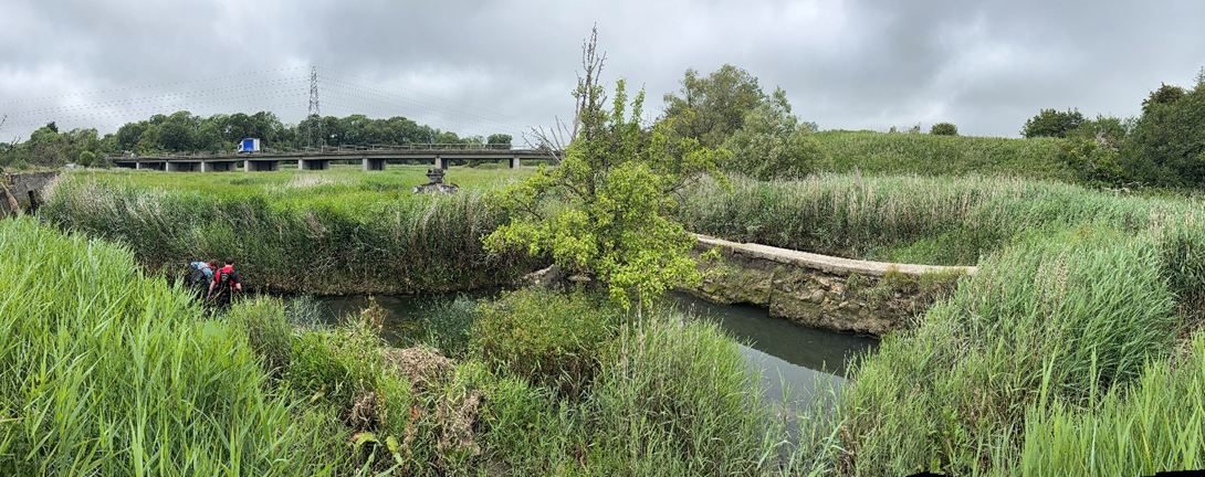
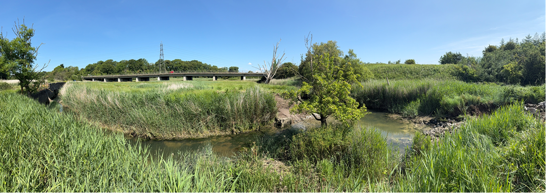
The first phase of improving the Kenson River WFD status was completed in summer 2025, by removing the failing weir at the south-west end of the river within the Fonmon Estate. The removal of this barrier will benefit wildlife at a local level and will also enable larger scale improvement opportunities in conjunction with the wider Kenson River restoration project.
The benefits of the weir are restoration of connectivity, benefiting biodiversity and water quality, as well as the removal of barriers to fish movement, and the restoration of natural river functions and sediment transfer. The removal will also reduce localised erosion and scour, as well as increasing the capacity of the channel during flood events and high tides.
Before weir removal
After weir removal
Useful resources
Areas
- Rhoose
Audiences
- River restoration
Interests
- River restoration
Share
Share on Twitter Share on Facebook