Rhydymain Forest Resource Plan
Overview
Natural Resources Wales is responsible for the sustainable management of the publicly owned woodlands and forests of Wales. They are managed for the benefit and well-being of the people who visit them and depend on them for their livelihood. This responsibility includes improving their biodiversity and long-term resilience to climate change so that future generations will also be able to enjoy the benefits they provide. Every ten years Natural Resources Wales reviews the long-term management plans for each forest area. These are compiled in a new Forest Resource Plan.
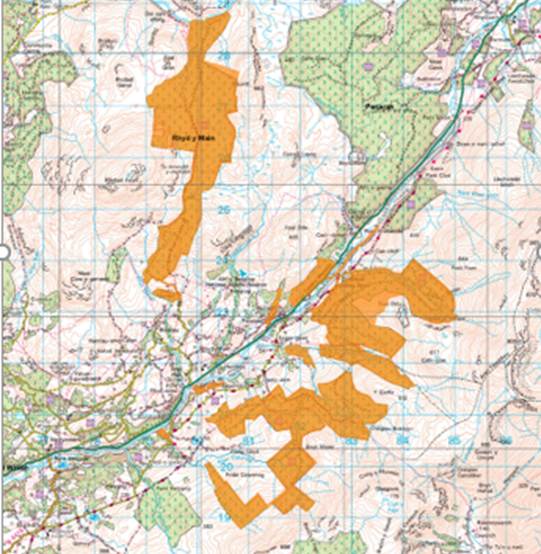
The Rhydymain forest areas are situated to the northwest and South East of the Afon Wnion. It includes two main forest areas known as Cae’r Defaid and Rhydymain. Total area 1155ha.
These areas together will now make up the Rhydymain Forest Resource Plan (See map below).
It is situated within the Planning Authority zone of Gwynedd County Council and it is all within the Snowdonia National Park. Visually most of Cae’r Defaid is largely hidden but some of the southern part of Cae’r Defaid and large parts of the Rhydymain block are visible from a number of locations including the village of Brithdir, the A470 south of Dolgellau and the Aran mountains ridge, to the south – parts of the Rhydymain block are visible from the village of Rhydymain itself. Some limited views occur from the A494 between Dolgellau and Bala.
All of the forest is within the Afon Mawddach, (Mostly via the Afon Wnion) water catchment.
Cae’r Defaid (455ha)- Situated mainly in a remote area between Rhobell Fawr to the west and Dduallt to the east, at the end of a minor council road to the north of Rhydymain village. Considerable felling of first rotation has occurred. Removal of one poor landscaping feature to the south was removed. To the west of the large Migneint-Arenig-Dduallt SSSI, SAC and SPA
Rhydymain main blocks (676ha) – A more visible block between the main A494 (Dolgellau to Bala section) and the Aran mountains ridge. Quite visible but a number of landscape issues have already been addressed. Its closest community is the village of Rhydymain
Wenallt blocks adjoining main A494 road – Two small blocks (also several other small minor areas Esgair Gawr and Lletty Wyn immediately adjacent to the main A494 road.
Summary of objectives
-
- Increasing the diversification of age, species and structure when possible to increase resilience to pests and disease whilst improving resilience to climate change.
- Regular thinnings are done to improve ecological diversity and increase options for future management including possible use of low impact silvicultural systems. This will maximise timber production and increase use of natural processes (natural regeneration)
- Look at all opportunities to increase structural diversity within stands through adopting a variety of silvicultural systems if possible
- Create a diverse permanent forest structure and ecosystem that includes riparian and (new) native woodland, natural reserves, long-term retentions, successional woodland and a mosaic of open habitats including forest roads and rides. Allow for a variety of woodland management regimes where natural processes only take place. This will benefit forest structure but will also provide important permanent habitat for a variety of fauna and flora (e.g Goshawk nest sites or lichen habitats).
- Increase use of natural processes (Natural Regeneration) where appropriate in establishment of new crops, particularly native broadleaf species.
-
- Continue to be a highly productive forest for timber production, utilising as much as possible a diversity of quality (timber) tree species that will flourish both now and into the future according to climate change predictions and should continue to maintain a regular sustainable supply of timber
- Continue to explore the potential for any sustainable renewable energy projects within the forest area. Continue to support the existing Hydro schemes in the Rhydymain main block (including those licenced but yet to be constructed/completed).
- Look for opportunities for supporting local businesses, local marketing of timber and other products/activities.
- The forest is a source of local employment, ensure this is maintained and look for opportunities for increased employment directly or indirectly both in timber production and other activities within the forest
- Utilise the watercourses, existing native woodland habitats, upland open habitats as the basis of a permanent forest structure, creating larger habitat networks with improved linkages with ancient woodland where possible, this linked network of riparian and native woodland will improve water quality and enhance biodiversity.
-
- Identify areas of deep peat to restore and remove the areas of poorly grown commercial crops.
- Manage the extent of clearfells within water catchments, to minimise impact on the water fluxes (peak flows) and critical loads where in an acid sensitive catchment.
- Protect and enhance the ecological condition of the Ancient Semi-Natural Woodland, protect all features of ancient woodland and improve the condition of all Planted Ancient Woodland Sites.
- Create or enhance open space or successional woodland in areas of deep peat (Mainly in the Cae’r Defaid block but also scattered smaller areas elsewhere, possibly linking with open upland habitat (See below adjacent designated area - Migneint-Arenig-Dduallt SPA, SAC, SPA and SSSI)), native woodland and riparian zones. Take action to restore deep peat areas where recommended.
-
- Create an appropriate plan to protect and manage the heathland/bog habitat (Migneint-Arenig-Dduallt SPA, SAC, SPA and SSSI) from productive conifers, this can include – the creation of an upland native woodland habitat, new open space (linked to peat restoration) and/or planned regular removal of non-native species from the designated areas between forest and heathland.
- Minimise the potential adverse effects of acidification through maintaining good and improved water quality through improved riparian habitat and linkages, increased area of native woodland and improved habitat networks based on the riparian infrastructure. The plan should aim to ensure all forest operations seek best standards.
- Increase the opportunities for deadwood habitat through identifying Long-term Retentions, Natural Reserves but also within all areas by changing operational habits, leaving deadwood (windblow) in situ, all which supports a diverse biota within the forest ecosystem.
- Activities to reduce flood risk include - riparian habitat improvement, increased use of smaller clearfells, planned extent of clearfelling within catchments, increased thinning, maintaining woodland cover and expansion of the native woodland area.
-
- Improve the visual diversity of the forest by increasing the structural diversity and species diversity within and between stands and increased native woodland and riparian habitats
- There are numerous minor historical features (Including old farmsteads, stone walls etc) which need both protecting and if possible, enhancing with either open space or native woodland expansion.
- Maintain PRoW and ensure they are taken into account during operational actives and blockages are reinstated as necessary
- Maintain existing level of activities such as motor rallies, enduros and horse events, maintain and improve current links with local communities to ensure current levels of access and usage are in line with local needs
Below is a pdf of the Draft Plan:
Map 1 Long-term Vision
Map 2 Forest Management and Clearfelling
Map 3 Forest Types and Restocking
This document helps to explain some of the categories shown on the maps below:
Why your views matter
We would like to know your opinion and views on the new plans for Rhydymain so it can help us improve the long-term management of the forest.
What happens next
We will look at what you have said to help us develop the plans.
Areas
- Brithdir and Llanfachreth/Ganllwyd/Llanelltyd
- Dolgellau North
- Dolgellau South
- Llanuwchllyn
Audiences
- Anglers
- citizens
- Coal Authority
- Cockles
- Community Volunteers
- DCWW
- Educators
- Flooding
- Fly-fishing
- Forest Management
- Gwirfoddolwyr Cymunedol
- Llifogydd
- marine developers
- marine planners
- Newport Green and Safe Spaces
- NFU
- SoNaRR2020
- South West Stakeholder group
- water companies
Interests
- Forest Management
- Rheoli Coedwig
Share
Share on Twitter Share on Facebook